Today’s real estate market demands more than static photographs and floor plans. Buyers expect immersive, detailed property visuals that let them explore spaces remotely with confidence, and sellers want their listings to stand out in an increasingly competitive digital landscape. For agents caught in the middle, choosing the right imaging technology has become a critical business decision that directly impacts client satisfaction and closing rates.
Two primary approaches dominate the conversation: LiDAR scanning, which uses laser pulses to map environments with extraordinary precision, and traditional methods like photogrammetry and standard photography that rely on capturing and processing visual imagery. Each brings distinct strengths to the table, but they differ significantly in speed, accuracy, and the quality of virtual experiences they produce. So which technology truly serves the needs of modern real estate professionals who must deliver compelling listings and seamless virtual tours? The answer requires a closer look at how each method works, where it excels, and where it falls short in practical property marketing scenarios.
The Evolution of Property Imaging: From Photos to Point Clouds
For decades, real estate marketing relied almost exclusively on photography. Agents would hire photographers to capture a property’s best angles, producing flat images that left buyers guessing about room dimensions, spatial flow, and how furniture might fit. Wide-angle lenses helped but also distorted proportions, sometimes creating unrealistic expectations that led to disappointment during in-person showings.


The introduction of 3D scanning fundamentally changed what was possible. Rather than capturing a scene from a single vantage point, these technologies gather spatial data from every direction, measuring distances between surfaces to construct complete digital representations of physical spaces. The result is a digital twin—a navigable, measurable 3D model that replicates a property with far greater fidelity than any photograph could achieve. Buyers can virtually walk through rooms, gauge ceiling heights, and understand how spaces connect without ever stepping inside.
This shift from passive imagery to active spatial measurement created two distinct technological paths. One relies on processing visual information from cameras to infer three-dimensional geometry. The other uses laser energy to directly measure the environment with scientific precision. Understanding how these approaches differ—and where each delivers the most value—is essential for any agent looking to invest wisely in their imaging workflow.
Understanding Traditional 3D Scanning Methods
In the context of real estate imaging, “traditional” 3D scanning refers primarily to photogrammetry—a technique that reconstructs three-dimensional geometry by analyzing overlapping two-dimensional photographs taken from multiple angles. A photographer captures hundreds, sometimes thousands, of images while moving systematically through a property. Specialized software then identifies common reference points across these images, triangulates their positions in space, and assembles a textured 3D model that viewers can navigate.
Photogrammetry has earned its place in real estate for good reasons. It produces richly textured models with excellent color accuracy since the source material is actual photography. The barrier to entry remains relatively low—agents can start with a quality camera they may already own, and processing software ranges from free open-source options to affordable subscriptions. The resulting virtual tours feel familiar and visually appealing, making them effective marketing tools for standard residential listings.

However, the method carries meaningful limitations that become apparent in professional practice. Lighting inconsistencies between shots can confuse stitching algorithms, producing visible seams or geometric errors in the final model. Reflective surfaces like mirrors, glass, and polished countertops create phantom geometry that requires manual cleanup. Measurement accuracy typically falls within a range of one to five centimeters—acceptable for visual tours but insufficient when buyers or contractors need reliable dimensions. Perhaps most critically for busy agents, processing times can stretch from several hours to overnight, and capturing enough source images for a complete property often takes considerably longer than alternative methods. These constraints become especially pronounced in large commercial spaces or properties with complex architectural features.
How LiDAR Technology is Revolutionizing Architectural Scanning
LiDAR—Light Detection and Ranging—takes a fundamentally different approach to capturing three-dimensional space. Instead of inferring geometry from photographs, a LiDAR device emits thousands of laser pulses per second, measuring the precise time each pulse takes to bounce off a surface and return to the sensor. These individual distance measurements accumulate into dense point clouds containing millions of data points, each with an exact spatial coordinate. The result is a mathematically precise skeleton of the scanned environment that software then renders into navigable 3D models.
For real estate professionals, this approach eliminates many frustrations associated with photogrammetry. A 3D LiDAR scanner captures complete rooms in seconds rather than minutes, dramatically reducing on-site time. Accuracy reaches millimeter-level precision, meaning measurements extracted from the resulting model are reliable enough for renovation planning, furniture fitting, and contractor estimates. Because laser pulses don’t depend on ambient illumination, LiDAR performs consistently whether scanning a sunlit penthouse or a windowless basement—lighting conditions that would compromise photo-based methods simply don’t affect the data quality.

The technology also handles challenging architectural elements with remarkable composure. Complex ceiling details, narrow hallways, and spaces partially obscured by staging furniture are captured without the gaps or distortions that plague photogrammetry in similar conditions. Modern LiDAR scanners designed for architecture range from handheld portable devices that an agent can carry through a property to tripod-mounted systems suited for large commercial spaces. This versatility, combined with increasingly streamlined processing workflows, positions LiDAR as the technology reshaping expectations for what property imaging can deliver.
Head-to-Head Comparison: Key Factors for Real Estate Agents
When evaluating these technologies through the lens of daily real estate operations, clear winners emerge across the categories that matter most. In speed of data capture, LiDAR dominates decisively—a complete residential property scan takes fifteen to thirty minutes compared to one or two hours for comprehensive photogrammetry coverage. For agents juggling multiple listings and tight schedules, this difference alone can justify the technology choice.
Accuracy and measurement detail again favor LiDAR, delivering millimeter-precision data that clients can trust for renovation budgets and space planning, while photogrammetry’s centimeter-range accuracy serves visual purposes but falls short for practical decision-making. In low-light environments and large commercial spaces, LiDAR maintains consistent performance regardless of conditions, whereas photogrammetry struggles without supplemental lighting and requires exponentially more images as square footage increases.
Ease of use has shifted considerably as LiDAR devices have become more intuitive. Modern handheld scanners require minimal training—walk through the property at a natural pace and the device handles the rest. Photogrammetry demands more technical knowledge around overlap percentages, lighting management, and post-processing cleanup. Final output quality for virtual tours is where the comparison becomes nuanced: LiDAR produces geometrically flawless models with reliable spatial relationships, while photogrammetry can deliver richer surface textures. However, current LiDAR systems increasingly incorporate high-resolution cameras that capture color data alongside spatial measurements, effectively closing this gap and delivering both precision and visual appeal in a single scan session.
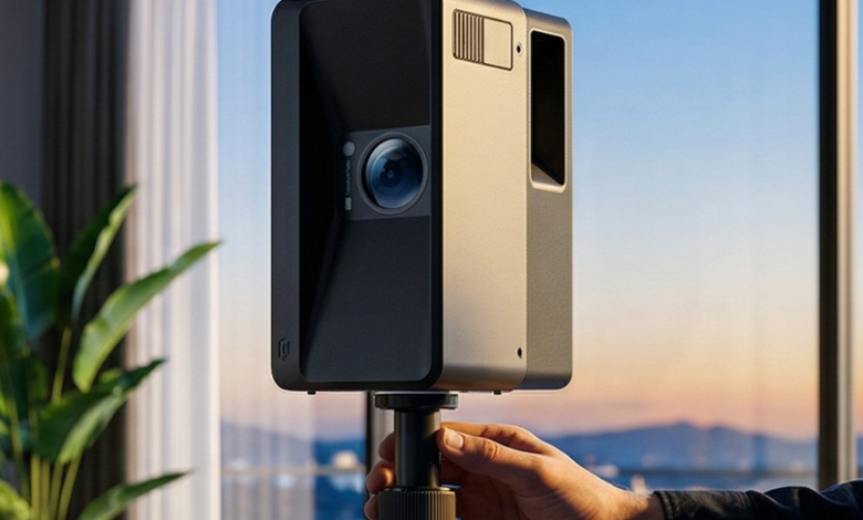
Case in Point: Implementing a LiDAR Scanner like the Galois P4
Theory only matters when it translates into practical tools agents can actually deploy in the field. The Galois P4 represents the kind of modern LiDAR scanner for architecture that bridges the gap between professional-grade spatial capture and everyday usability. Designed with portability as a priority, it weighs little enough to carry comfortably through multi-story properties without fatigue, yet delivers the dense point cloud data that produces stunning, dimensionally accurate virtual tours.
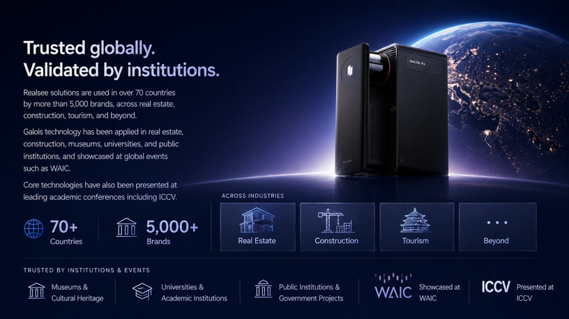
What makes devices like the P4 particularly relevant for real estate work is their integration philosophy. The scanner pairs with intuitive processing software that automates much of the model generation pipeline, meaning agents spend less time wrestling with technical workflows and more time marketing properties. Real-time feedback during scanning shows coverage progress, eliminating the anxiety of discovering missed areas only after leaving the property. The resulting models export cleanly to popular virtual tour platforms like Realsee, MLS-compatible formats, and architectural planning tools—giving agents flexibility in how they present listings to different audiences.
For professionals committing to LiDAR as their primary imaging solution, a premium bundle approach makes strategic sense. These typically include extended battery sets for scanning multiple properties in a single day without recharging interruptions, protective carrying cases built for the demands of constant travel between listings, and full software licenses that unlock advanced features like automated floor plan generation and measurement annotation. Rather than piecing together components individually, a bundle ensures agents have everything needed to operate professionally from day one, reducing the friction between purchasing the technology and generating revenue from it.
See also: Anti-Static Raised Flooring Solutions for High-Tech and Commercial Environments
Your Step-by-Step Guide to Adopting LiDAR for Property Listings
Moving from traditional photography to LiDAR scanning doesn’t require a complete overhaul of your workflow—it requires a structured approach that becomes second nature after a few properties. Here’s how to integrate this technology into your listing process effectively.
Start with property preparation. Before arriving with your scanner, coordinate with sellers to declutter surfaces, open all interior doors, and turn on lights in windowless rooms. While LiDAR handles low light beautifully, the integrated cameras that capture color data still benefit from reasonable illumination. Walk the property first without scanning to identify any areas that might require multiple passes, such as tight closets or L-shaped rooms with limited sightlines.
During the scan itself, move through the property at a steady, unhurried pace. Most handheld LiDAR devices work best when you walk naturally while keeping the scanner oriented toward the areas you want to capture. Overlap your coverage between rooms by pausing briefly in doorways, ensuring the software can stitch adjacent spaces seamlessly. For multi-level properties, scan each floor completely before moving to the next, capturing staircases from both top and bottom to maintain geometric continuity.
Once on-site capture is complete, data processing transforms raw point clouds into polished 3D models. Import your scan data into the paired software, verify coverage completeness using the preview tools, and initiate automated model generation. Most modern platforms handle alignment, meshing, and texture mapping without manual intervention, delivering a finished model within minutes rather than hours. Review the output for any artifacts and apply quick corrections where needed.
Finally, export your completed model to virtual tour platforms, generate shareable links for MLS listings, and extract floor plans with accurate measurements for marketing materials. Many agents find that annotating key dimensions directly on the model—room sizes, ceiling heights, window widths—adds immediate value that distinguishes their listings from competitors still relying on flat photography alone.
Why LiDAR Is the Future of Real Estate Imaging
The comparison between LiDAR and traditional scanning methods reveals a clear trajectory for real estate imaging. While photogrammetry served the industry well during the early years of 3D property visualization, LiDAR delivers decisive advantages in the areas that matter most to working agents: capture speed measured in minutes rather than hours, millimeter-level accuracy that clients can rely on for real decisions, and consistent performance regardless of lighting conditions or architectural complexity.
For real estate professionals committed to providing top-tier virtual tours and dimensionally accurate listings, investing in LiDAR technology represents more than a workflow upgrade—it’s a strategic positioning decision. Buyers increasingly expect interactive, measurable 3D experiences before scheduling showings, and agents equipped with LiDAR can deliver these experiences faster and with greater reliability than those still dependent on photo-based reconstruction. As the technology continues to become more portable, more affordable, and more deeply integrated with PropTech platforms like Realsee, LiDAR is transitioning from a competitive advantage to a baseline expectation in premium real estate marketing. Agents who adopt it now build expertise and client trust that will compound as the standard rises across the industry.